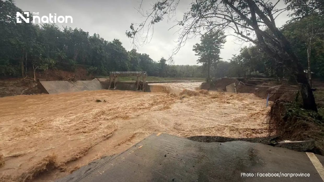
A deluge of more than 110 millimetres of rain overnight triggered severe flash flooding across Pua district in Nan province, northern Thailand on Wednesday morning, turning residential neighbourhoods and agricultural land into disaster zones whilst rendering several critical roadways impassable. The torrential downpour, which began in the early hours of Wednesday and continued relentlessly through the forested headwater regions of Phu Kha subdistrict, unleashed rapid runoff that caught many communities off guard, leaving residents scrambling to seek higher ground as water inundated their homes and surrounding areas.
The Doi Phu Kha National Park office, situated in the affected upland zone, confirmed the severity of the rainfall measurement at just over 110 millimetres—a significant volume in such a compressed timeframe that transformed natural drainage systems into torrential watercourses. Early morning reports around 6am painted a picture of ongoing crisis conditions, with communities in Ban Rong and Ban Na Lae among those most severely impacted by the floodwaters. Residents had minimal time to evacuate belongings, household electronics and family pets to elevated spaces before the advancing water breached their homes, resulting in substantial property damage across multiple settlements.
The physical infrastructure damage compounded the humanitarian crisis significantly. In Ban Na Lae, positioned along the route towards Doi Phu Kha National Park and Bo Kluea district, a bridge was completely washed away, rendering the road completely impassable and isolating residents from supply routes and emergency services. Additional infrastructure failures included another bridge at the Fai Chao weir area that succumbed to the floodwaters, further fragmenting the region's transport network. The Department of Highways, specifically Nan Highway District 2, surveyed the damage and identified three critical junctures where vehicles could no longer safely traverse the affected roadways, subsequently issuing comprehensive traffic advisories to redirect travellers.
Compounding the flooding were reports of landslides blocking roads in Ouan subdistrict, multiplying access difficulties for rescue personnel attempting to reach vulnerable communities. These secondary disasters, triggered by prolonged rainfall saturating hillsides, presented additional obstacles to emergency response efforts. The cascading nature of these events—flooding combined with landslides and bridge collapses—created a complex humanitarian scenario requiring coordinated response from multiple agencies and departments.
The Nan Provincial Disaster Prevention and Mitigation Office immediately activated its emergency protocols, issuing regular situation reports and preparing for evolving conditions. Recognising the critical need for rapid public notification, the Department of Disaster Prevention and Mitigation partnered with major telecommunications operators AIS, True and NT to disseminate an extreme weather alert through the Cell Broadcast system to all mobile phones in Pua district. The official message urged residents to immediately relocate their possessions and vulnerable household members, including elderly persons and patients with mobility limitations, to safe elevated areas whilst directing those requiring assistance to contact their subdistrict administrative heads, village leaders or local government organisations.
The meteorological background revealed that weather systems across northern Thailand were generating widespread precipitation. The Northern Meteorological Centre of the Thai Meteorological Department identified multiple rain bands tracked by Lamphun weather radar, with light to moderate precipitation affecting nine provinces across the upper North region. These rain bands were moving systematically towards the south-west, suggesting potential for similar conditions to affect adjacent areas in coming hours. Such regional weather patterns indicated that Pua's experience might represent the initial impact of a broader system affecting the northern highlands.
For Malaysian and Southeast Asian observers, the Pua flooding illustrates vulnerabilities that transcend borders in the region. Northern Thailand's topography—with steep-sided forested valleys and rapid drainage systems—parallels conditions in Malaysia's own northern and eastern regions, particularly Peninsular Malaysia's hill stations and Sabah and Sarawak's upland areas. The speed with which 110 millimetres of rainfall generated critical flooding demonstrates how climate patterns affecting one country's northern territories can serve as early warning systems for similar precipitation events moving across the broader region. The integration of modern alert systems using mobile technology offers a model worth examining for regional adaptation.
The incident also underscores broader climate dynamics affecting mainland Southeast Asia and the wider region. The monsoon systems that bring seasonal rainfall to Thailand equally influence weather patterns across Malaysia, Myanmar, Laos and Cambodia. Increased precipitation intensity in individual weather events, whether driven by climate variability or longer-term climate change trends, presents consistent challenges to all nations in the region—particularly those with significant rural and agricultural populations dependent on predictable rainfall patterns rather than destructive flash events.
From an infrastructure perspective, the bridge collapses at Ban Na Lae and Fai Chao highlight vulnerabilities in regional transport networks when faced with hydrological extremes. Similar weaknesses exist throughout Southeast Asia, where aging infrastructure and rapid drainage patterns create conditions where nominally routine rainy season events can become catastrophic infrastructure failures. Upgrading rural bridges and roads in flood-prone areas remains a consistent challenge across the region, with capital constraints and competing development priorities often deprioritising what communities perceive as maintenance issues until disasters make them suddenly visible and urgent.
The coordination demonstrated between Thai authorities—from meteorological services through disaster prevention and mitigation agencies to telecommunications providers and highway departments—offers insights into multi-agency disaster response. The cell broadcast system, which reaches citizens directly without requiring active internet connectivity, represents technology increasingly adopted across Southeast Asia as countries strengthen their disaster alert capabilities. Malaysia, through its own meteorological and disaster management agencies, continues developing similar integrated warning systems to improve public safety outcomes during extreme weather events.
For the immediate future, the focus in Pua district remained on search and rescue operations, assessment of damage extent, and restoration of critical infrastructure particularly transport routes isolating communities. The situation underscored how rapidly weather systems can transition from meteorological phenomena into humanitarian crises affecting thousands of residents, destroying livelihoods built on agriculture, and severing the infrastructure connections upon which rural economies depend.

