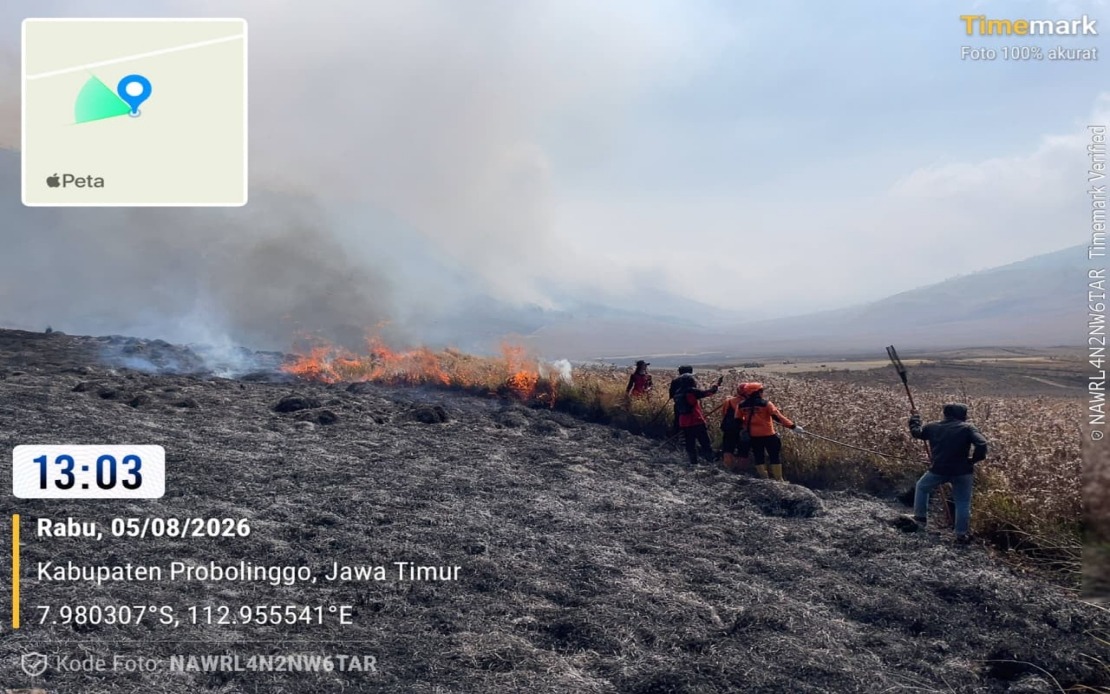
A significant wildfire continues to spread across Indonesia's Mount Bromo region, prompting emergency responders to escalate containment efforts with aerial support. The National Disaster Management Agency (BNPB) has mobilized two water-bombing helicopters to address the blaze, which has consumed roughly 60 hectares of terrain across East Java's Probolinggo and Malang regencies. The fire, which ignited on Monday, represents a substantial challenge for ground-based firefighting operations due to the challenging topography of the volcanic landscape.
According to Abdul Muhari, head of BNPB's Disaster Data, Information and Communication Centre, the affected areas encompass approximately 10 hectares within Probolinggo Regency proper and an additional 50 hectares within the Bromo Tengger Semeru National Park located in neighbouring Malang Regency. The distribution of the fire across multiple jurisdictions has necessitated coordination between local authorities and national disaster management teams to ensure comprehensive response efforts.
The deployment of aerial resources underscores the particular difficulty presented by the terrain where the fire has taken hold. Many of the remaining active hotspots are concentrated on steep mountain slopes that prove largely inaccessible to conventional ground-based firefighting crews. The helicopters' capacity to deliver water directly onto these elevated and treacherous areas represents a critical tactical advantage that ground teams alone cannot provide, making the aerial intervention essential to preventing further spread.
By Wednesday afternoon, emergency personnel had successfully contained the majority of the active flames, demonstrating the effectiveness of coordinated ground and early response efforts. However, numerous hotspots remain stubbornly active in the most challenging terrain, requiring continued vigilance and tactical deployment of resources. The ongoing monitoring operation reflects the unpredictable nature of wildfire management in mountainous regions, where seemingly controlled areas can reignite unexpectedly.
Beyond the helicopter response, BNPB is preparing additional intervention measures should conditions permit. A Weather Modification Operation is currently under preparation and will be deployed contingent on favourable atmospheric conditions. This operation would complement the existing ground-based firefighting activities being conducted by the multi-agency emergency response team, representing an integrated approach to managing the crisis across multiple intervention levels.
The Bromo Tengger Semeru National Park Authority has implemented a temporary closure of designated portions of the Mount Bromo tourist area to support firefighting operations and safeguard public safety. This precautionary measure reflects the inherent dangers posed by active wildfires to civilian visitors and the logistical complications that tourist presence creates for emergency response teams. The timing and extent of the reopening will depend on the successful containment and full extinguishing of all active fire zones.
Investigations into the fire's origins suggest that the initial spark likely originated from a campfire improperly extinguished by hikers, though formal cause determination remains ongoing. This theory aligns with well-documented patterns of wildfire ignition in popular trekking destinations, where visitor behaviour and inadequate fire management protocols frequently contribute to landscape-scale conflagrations. The incident underscores the critical importance of public education regarding fire safety in ecologically sensitive areas.
The Mount Bromo wildfire incident carries broader implications for Southeast Asian disaster management and tourism sustainability. As the region experiences intensified pressure from tourism growth and climate patterns that extend dry seasons, wildfire risk management has emerged as an essential component of national emergency preparedness. Indonesia's response demonstrates the necessity of maintaining robust aerial firefighting capabilities and inter-agency coordination mechanisms that can mobilize rapidly when crises emerge.
For Malaysian readers and regional observers, the Mount Bromo situation serves as a useful case study in wildfire management across difficult terrain. Similar challenges confront forest management and emergency response agencies throughout Southeast Asia, where mountainous geography and dense vegetation create conditions conducive to rapid fire spread. The integration of aerial resources with ground-based efforts, combined with strategic park closures, represents a template increasingly relevant across the region.

