The Malaysian Meteorological Department issued a weather alert on June 28 affecting multiple regions across peninsular Malaysia, warning residents and commuters to brace for hazardous conditions through the early hours of the following day. The advisory highlights the need for heightened vigilance as unstable atmospheric conditions develop across the country's northern and eastern corridors, with thunderstorms and intense rainfall expected to dominate the overnight period.
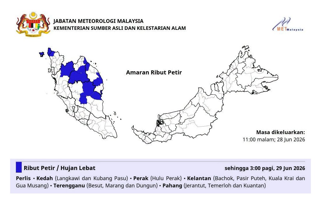
Perlis faces the full brunt of the incoming weather system, with the entire state placed under alert status. The neighbouring state of Kedah will experience similar conditions concentrated in specific districts including the island of Langkawi and the Kubang Pasu area, both traditionally vulnerable to flash flooding during heavy downpours. These regions require particular attention given their topography and historical susceptibility to rapid water accumulation in low-lying zones.
In the Perak region, forecasters have pinpointed Hulu Perak as the primary zone of concern, an area characterised by elevated terrain and river systems prone to swelling during intense rainfall. The mountainous nature of upper Perak means that torrential downpours can quickly translate into dangerous flash flood conditions affecting communities downstream, necessitating precautionary measures by local authorities and residents alike.
The east coast states face similarly volatile conditions. Kelantan's alert covers multiple districts spanning Bachok in the northern coastline through to the inland areas of Pasir Puteh, Kuala Krai and Gua Musang, reflecting the geographical spread of unstable weather patterns across the state. These regions, already familiar with monsoon-related disruptions, require residents to remain vigilant and prepared for potential infrastructure impacts.
Terengganu's warning encompasses the coastal and semi-coastal districts of Besut, Marang and Dungun, areas where thunderstorms can create challenging conditions for maritime activities and low-lying residential zones. The combination of heavy precipitation and strong winds typical of such weather systems poses risks to fishing communities and coastal infrastructure throughout the night.
Pahang's affected zones include Jerantut, Temerloh and Kuantan, covering both inland and coastal regions of the state. Kuantan, as a major population centre and economic hub on the east coast, warrants particular monitoring given the potential for disruptions to transport networks and commercial activities if severe weather persists. Temerloh and Jerantut, situated along river systems, could experience elevated water levels requiring close observation.
The alert duration extending until 3 am suggests that meteorologists anticipate the weather system will maintain its intensity through the late evening and early morning hours, a critical window when traffic volumes on highways may increase as people travel to work. Commuters and road users should exercise extreme caution, as visibility reduction caused by heavy rain combined with strong winds creates hazardous driving conditions.
The simultaneous issuance of multiple warnings across geographically dispersed regions indicates a broad-based weather disturbance affecting multiple states rather than isolated localised storms. Such widespread alerts typically prompt coordinated responses from civil defence agencies, local councils and emergency services to ensure public safety and rapid response capabilities to any weather-related incidents.
Residents in the affected areas are advised to secure loose outdoor items, avoid unnecessary travel during peak rainfall periods, and monitor official updates from MetMalaysia throughout the night. Particular caution applies to those in flood-prone areas who should consider relocating to safer ground if previous experience suggests vulnerability to inundation. Drivers traversing highways linking these states should reduce speed and maintain heightened awareness, as hydroplaning and reduced visibility represent significant hazards during thunderstorms of the magnitude being forecast.