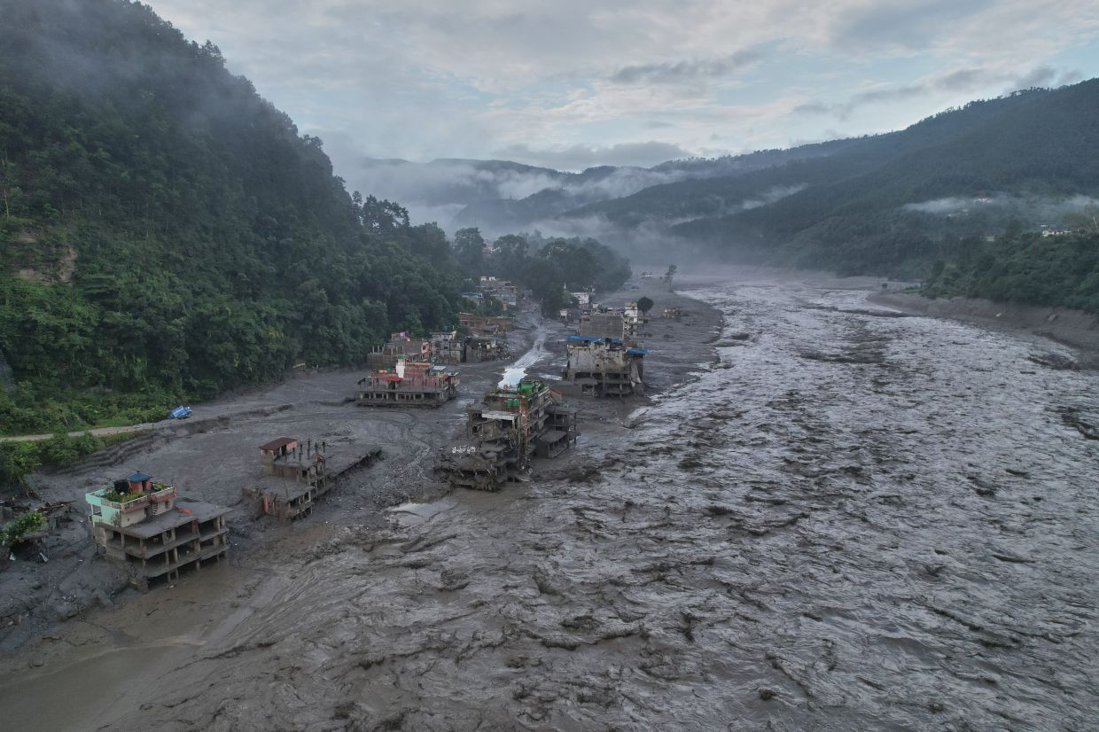
The devastating floods that swept through Nepal last week claimed at least 800 lives and left more than 3,000 people missing, but perhaps most troubling was how little advance notice residents received. According to Dharam Raj Uprety, chief executive of Nepal's National Disaster Risk Reduction and Management Authority, affected communities had barely five minutes of warning before the catastrophic surge of water, ice and debris descended upon them. This tragic shortfall in reaction time reflects deeper systemic failures in the region's disaster preparedness infrastructure, particularly the alarming lack of functional weather monitoring stations across the high-altitude areas where such disasters originate.
The root cause of this critical gap lies in Nepal's inability to establish adequate meteorological infrastructure in the Himalayas and, equally important, the limited mechanisms for sharing climate and weather data across international borders with neighbouring China. Uprety acknowledged that the absence of trans-boundary data-sharing protocols represents one of the country's most pressing challenges in disaster risk management. Without weather stations positioned strategically throughout Nepal's mountain regions, authorities operate essentially blind to the rapidly changing conditions that can trigger catastrophic events. The economic and logistical barriers to installing and maintaining such stations at extreme altitudes remain formidable, leaving vast stretches of the Himalayan range inadequately monitored despite their potential to generate disasters affecting millions downstream.
China's leadership has begun signalling greater urgency around this shared vulnerability. President Xi Jinping called for accelerated surveys of glaciers and glacial lakes across the Tibetan Plateau to prevent future disasters, according to state media Xinhua News Agency. Days after the Nepal disaster, China's Communist Party issued directives for stronger monitoring systems and improved early-warning capabilities to help authorities identify interconnected disaster risks before they materialise. However, transparency regarding actual information exchange remains murky. When the Chinese Embassy in Nepal issued a statement via social media platform X, it claimed that China consistently endeavours to monitor, assess and analyse conditions while sharing important findings with Nepali counterparts in a timely fashion. The statement notably stopped short of clarifying whether China had issued any specific warning about the August 26 catastrophe that ultimately devastated the region.
Satellite analysis revealed that the immediate trigger for the August 26 disaster was the sudden collapse of bedrock beneath a glacier, unleashing a violent cascade of ice, mud, rocks and torrential floodwater through a valley system. The resulting torrent obliterated entire villages, swept away bridges and power infrastructure, and stripped the landscape of trees, boulders and vehicles. Video footage captured the terrifying moments as people fled desperately ahead of water walls and debris. Scientists emphasise that while climate-related warming demonstrably weakens the permafrost that binds high-altitude slopes together, attributing this specific collapse directly to anthropogenic climate change remains premature. Nevertheless, the pattern of accelerating glacier destabilisation as temperatures rise underscores a broader threat affecting the entire Himalayan chain as the region continues to warm faster than the global average.
The financial implications of this disaster are staggering. Binod Chaudhary, Nepal's only billionaire and chairman of the Chaudhary Group conglomerate, estimated that reconstruction costs may exceed US$5 billion—a burden comparable to the seven-to-eight year rebuilding process that followed the devastating 2015 earthquake. For a lower-middle-income country like Nepal, such expenditure diverts resources from development priorities and strains governmental capacity. Beyond immediate reconstruction, the disaster threatens tourism revenues, a cornerstone of Nepal's foreign exchange earnings and employment base, particularly in regions dependent on mountaineering and trekking operations. The cascading economic consequences will reverberate through Southeast Asia's tourism networks and supply chains for years to come.
The fundamental challenge confronting Nepal stems from the geography of disaster risk itself. While downstream areas possess adequate monitoring infrastructure, the high-mountain zones where actual hazards originate remain poorly observed and under-resourced. Installing weather stations at extreme altitudes demands specialised engineering, substantial capital investment and ongoing maintenance under brutal environmental conditions. The resulting deficit in real-time data on temperature fluctuations, permafrost stability and emerging glacial hazards severely constrains the authorities' capacity to detect warning signs sufficiently early. This asymmetry—where the zones of greatest vulnerability are simultaneously the least monitored—creates the dangerous scenario that killed hundreds in late August.
Recognising these systemic failures, Uprety has prioritised the development of more robust early-warning systems. His agency has drafted a comprehensive roadmap designed to extend warning periods and grant communities adequate preparation time before disaster strikes. The proposed framework addresses both technological upgrades and institutional mechanisms for cross-border information exchange. Implementation of this roadmap is expected to receive endorsement within coming months, signalling political acknowledgment of the crisis's urgency. However, translating policy directives into functional capacity across mountainous terrain riddled with logistical challenges remains a formidable undertaking requiring sustained international cooperation and funding.
The geopolitical dimension of this disaster extends beyond Nepal's borders. China's involvement in Himalayan monitoring and its willingness to share critical data with downstream nations will significantly influence regional resilience. Current arrangements appear ad-hoc and limited, lacking the formalised protocols and institutional frameworks necessary for genuine real-time information flow. Uprety pointedly noted that unless nations abandon restrictive approaches to sharing climate and weather information across boundaries, disasters originating in remote mountain areas will persistently evade anticipation. This argument resonates across Southeast Asia, where transboundary water systems, monsoon patterns and glacier-fed rivers create interdependent disaster risks that no single nation can manage in isolation.
For Malaysia and other Southeast Asian countries, Nepal's tragedy carries instructive lessons about the perils of incomplete climate and meteorological surveillance in shared geographical systems. The Himalayan disaster underscores how glacial collapse, glacial lake outburst floods and similar high-altitude phenomena can cascade through interconnected hydrological systems affecting downstream populations across multiple nations. Southeast Asia's own vulnerable mountainous regions, particularly along the Mekong River system and shared waterways, face comparable threats amplified by warming temperatures and changing precipitation patterns. Developing robust early-warning systems and genuine data-sharing mechanisms must become priorities for regional governments seeking to protect populations and critical infrastructure from escalating climate-driven hazards.
Looking forward, Nepal's experience demonstrates that disaster risk reduction in mountainous regions cannot be addressed through isolated national efforts alone. The scale of investment required to establish comprehensive monitoring networks, the technical expertise necessary to interpret real-time data effectively, and the political will needed to share sensitive meteorological information across borders all point toward the necessity of regional and international cooperation frameworks. Without binding agreements on data sharing, capacity building assistance from developed nations, and coordinated early-warning protocols, countries throughout South and Southeast Asia will continue facing preventable loss of life when mountain-based disasters strike. The cost of maintaining the current fragmented approach far exceeds the investment required to build comprehensive, integrated systems that transcend political boundaries.

