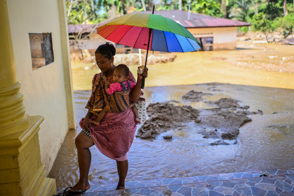
The Indonesian province of North Sumatra has been grappling with an unexpected deluge that defies the broader climatic trends sweeping across the archipelago. Over the past few days, severe flooding inundated numerous communities throughout the region, catching residents off guard as much of Indonesia experiences increasingly parched conditions. The flooding struck Binjai, Pematang Siantar and Simalungun on Friday, the result of heavy overnight rainfall that transformed streets and neighbourhoods into waterlogged zones, with floodwaters reaching knee-depth in many affected areas.
The impact on daily life has been substantial and multifaceted. In Pematang Siantar, the surging waters breached the Trans-Sumatra Highway, a crucial arterial link connecting the city to the provincial capital of Medan, creating significant congestion and disrupting the movement of goods and commuters across the region. The flooding also triggered secondary hazards: in Binjai, the violent downpour uprooted trees, with one incident leaving a street vendor selling meatballs with serious injuries. Such cascading effects underscore how extreme weather events in Indonesia often compound initial damage through secondary accidents and health crises.
Local residents in Simalungun Regency have described the frightening speed with which the disaster unfolded. Wan Agus Yahya, a community member, recounted how floodwaters surged into his neighbourhood during the early morning hours on Friday, submerging roads and forcing their way into homes. By mid-morning, the water had not fully receded, keeping residents in a state of heightened vigilance and uncertainty about when normalcy would return. This lingering situation reflects a broader vulnerability: communities in North Sumatra lack adequate drainage infrastructure and flood management systems to handle sudden precipitation events.
Frustration among residents has grown palpable, particularly because flooding has become cyclical rather than exceptional. Wan Agus highlighted a persistent grievance: the flooding recurs almost annually, yet government bodies have repeatedly failed to implement lasting remedial measures. His criticism points to a gap between disaster response and disaster prevention—authorities tend to mobilise resources only after emergencies strike, rather than undertaking the upstream interventions needed to reduce vulnerability. He expressed exasperation that residents continue to bear the burden of suffering preventable calamities while officials delay decisive action on drainage, embankment reinforcement and watershed management.
Emergency services mobilised rapidly to address the immediate crisis. Jhon Vhento Hasudungan Purba, heading the Preparedness Division at the Simalungun Disaster Mitigation Agency (BPBD), confirmed that seven emergency personnel were deployed to evacuate individuals trapped by rising waters. Officials issued stern public advisories urging residents to avoid traversing flooded zones and cautioning drivers against attempting to navigate submerged roads. The messaging emphasised that personal safety must supersede convenience, a critical communication given that vehicle submersion in deep floodwaters remains a leading cause of casualties during such events.
The meteorological forecast suggests the ordeal may persist. The Medan office of Indonesia's Meteorology, Climatology and Geophysics Agency (BMKG) projected that the rainfall would continue throughout Friday, with varying intensity ranging from light to moderate to heavy downpours. The agency identified a broad swathe of North Sumatra as vulnerable to further precipitation, encompassing Deli Serdang, Batubara, Tebing Tinggi, Serdang Bedagai, Simalungun, Labuhanbatu, South Labuhanbatu, North Labuhanbatu, Padang Lawas, Dairi, Humbang Hasundutan, Karo, Langkat, Pakpak Bharat, Samosir, North Tapanuli and Toba. This expansive geographic scope underscores that the flooding affects a major proportion of the province rather than isolated pockets.
Weather patterns are expected to intensify hazards in the coming period. Defri Mendoza, a BMKG meteorologist in Medan, noted that the anticipated rainfall would be accompanied by southerly to northerly winds at speeds between three and ten kilometres per hour, conditions that heighten the risk of cascading hydrometeorological disasters. He emphasised particular concern for mountainous terrain and the western slopes of North Sumatra, areas prone to receiving heavy rainfall that frequently triggers not merely flooding but also landslides. These compound disasters can prove especially lethal and destructive, as mountainside collapses can block evacuation routes and destroy critical infrastructure simultaneously.
The North Sumatra flooding paradoxically illustrates Indonesia's increasingly erratic and fragmented climate patterns. While substantial portions of the archipelago are entering or have already entered the dry season, certain regions continue to receive intense precipitation. This spatial variability complicates national-level disaster preparedness and suggests that cookie-cutter approaches to weather prediction and infrastructure resilience prove inadequate for an island nation with diverse microclimates and topographies. The situation reflects a fundamental challenge for Indonesian policymakers: adapting systems designed for traditional seasonal patterns to increasingly volatile climatic behaviour.
Broader climatic indicators suggest that such anomalies may become more common in coming months. As of late July, BMKG recorded that more than two-thirds of Indonesia had entered the dry season, with forecasts pointing toward below-normal rainfall persisting throughout the remainder of the year. The underlying driver appears to be intensifying El Niño effects, which reduce moisture transport from the Pacific Ocean toward Southeast Asia. Consequently, while North Sumatra currently battles unprecedented flooding, other regions—particularly in eastern Indonesia—are already confronting wildfires and drought conditions, indicating that the archipelago faces a year of climatic extremes at opposite poles of the precipitation spectrum. This divergence poses distinct challenges for agricultural output, water security, and disaster management across different provinces simultaneously.

