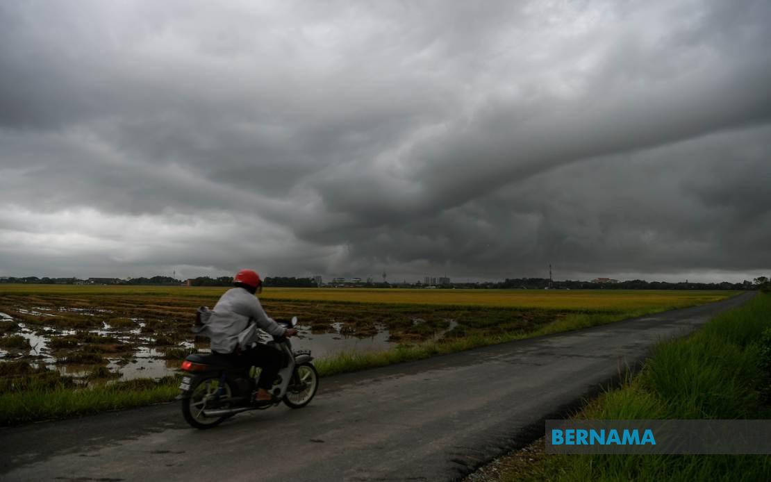
Malaysia's weather authorities have activated widespread alerts covering multiple regions of the country as unstable atmospheric conditions bring intense precipitation and gusty winds across a significant swathe of the nation. The Malaysian Meteorological Department issued the warning on July 4, cautioning residents and commuters to prepare for disruptions throughout the day.
The northern peninsula region faces particular vulnerability, with the alert encompassing five districts in Kedah—Kota Setar, Yan, Pendang, Kuala Muda, and Sik—where thunderstorm activity combined with torrential downpours poses risks to both urban and rural communities. The warning extends into Perak, affecting Manjung and Perak Tengah, two districts that have historically experienced significant flooding during intense rainfall events. These areas typically see increased waterlogging and traffic congestion when such weather systems develop.
The east coast experiences similar threats, with Kemaman in Terengganu and Kuantan in Pahang both under alert status. These districts, situated along Malaysia's east coast, frequently bear the brunt of atmospheric disturbances and are accustomed to rapid weather changes. The mountainous terrain in certain parts of Pahang also elevates concerns about hill slides and flash flooding in low-lying settlements adjacent to streams and rivers.
The Klang Valley and surrounding areas are not exempt from this weather system. Hulu Langat in Selangor, a district encompassing both urban sprawl and forested areas, falls within the warning zone. This region's proximity to Kuala Lumpur means disruptions could affect the nation's capital and surrounding industrial zones, potentially impacting commerce and transportation networks that thousands depend upon daily.
Negeri Sembilan's Jelebu and Seremban districts round out the peninsular coverage, with both areas recognised as flood-prone zones during periods of heavy precipitation. The state government and emergency services typically maintain heightened readiness during such weather events to manage evacuation operations if water levels rise unexpectedly.
East Malaysia faces equally significant threats, with Sarawak's maritime districts of Sarikei and Mukah—which encompasses Sibu, Tanjung Manis, and Daro—bracing for rough seas and intense rainfall. These coastal communities rely heavily on fishing and maritime trade, making adverse weather particularly consequential for livelihoods and supply chains. The combination of thunderstorms and strong winds poses hazards to small vessels operating in these waters.
Sabah's warning footprint encompasses three distinct regions reflecting the state's geographic complexity. The Interior Division, including Keningau and Tambunan, sits amid mountainous terrain where waterlogged roads and landslides become pressing concerns. The West Coast Division—Papar and Penampang—represents one of Sabah's most densely populated and economically active areas, where flooding disrupts daily activities for substantial populations. Sandakan's Kinabatangan district, spanning coastal and inland territories, faces compounded risks from both sea-state deterioration and inland water accumulation.
MetMalaysia's issuance of such comprehensive warnings reflects the meteorological department's assessment that atmospheric conditions have created an environment favourable for organised thunderstorm development across multiple regions simultaneously. The persistence of these conditions through 6pm suggests a system of sufficient scale and intensity to maintain activity throughout the afternoon and early evening hours.
For Malaysian residents and businesses, such warnings typically trigger preparatory measures including securing loose outdoor items, adjusting transportation schedules, and heightening vigilance around drainage systems and natural watercourse areas. Emergency services across the affected states generally position additional personnel and equipment in anticipation of weather-related incidents requiring rapid response.
The geographic spread of this alert—spanning from Kedah in the far north through the peninsula's spine and encompassing both East Malaysian states—underscores the synoptic-scale nature of the atmospheric pattern driving these conditions. Rather than isolated thunderstorm activity confined to particular microclimatic zones, this represents a broader weather system affecting the Malaysian region comprehensively.
Transportation infrastructure faces particular vulnerability during such events, with highways, airports, and ports potentially experiencing operational disruptions. Visibility limitations from heavy downpours and crosswind hazards pose risks to motorists, while aviation authorities typically implement enhanced monitoring protocols at affected airports. Maritime operators along both coasts exercise caution regarding departure and arrival schedules.
Agricultural activities also warrant consideration, as intense rainfall can overwhelm drainage systems in farming areas, potentially damaging crops or creating waterlogging conditions detrimental to agricultural productivity. Plantation operators and smallhold farmers in affected districts typically implement protective measures to minimise losses from excessive moisture accumulation.
Residents should monitor updates from MetMalaysia and relevant state authorities throughout the day, as weather forecasts may require adjustment based on real-time observations of system development and movement. The six-hour window through 6pm represents the period of greatest concern, though conditions may ameliorate gradually once the system moves through or weakens.