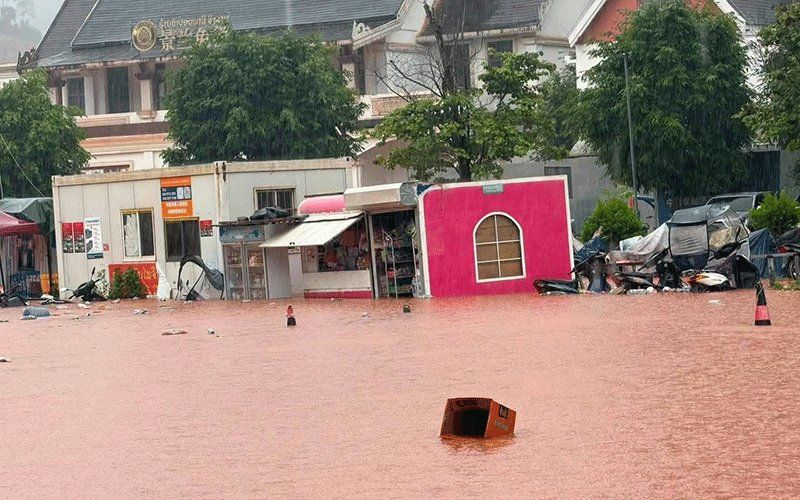
Northern Laos faces a mounting water crisis after Luang Namtha province was officially declared a disaster zone on Saturday, August 29, following destructive flash floods that swept across the region near the strategic Boten border crossing with China. The Luang Namtha Provincial Administrative Committee issued the declaration after assessing damage across more than 30 villages, where swelling waters inundated residential buildings, flooded the Boten special economic zone, destroyed cropland and damaged key infrastructure facilities. The sudden surge in water levels, triggered by relentless rainfall upstream over several preceding days, sent torrents of water flowing southward from higher elevation areas into the Laos lowlands.
The flooding affected multiple sectors across Luang Namtha and Nalae districts, with riverfront structures bearing the brunt of the deluge. Schools, hospitals and medical facilities sustained significant damage as water levels rose rapidly across the region. An airport serving the area also experienced flooding, though operational details remained limited. The Boten border checkpoint, which serves as a critical commercial gateway between Laos and China, managed to escape direct inundation, allowing cross-border trade and movement to continue despite the surrounding humanitarian crisis. However, the broader economic zone surrounding the checkpoint did not escape the waters' reach, threatening the investment climate and logistics operations in this strategically important trade corridor.
Hydrological data underscored the severity of the situation, with monitoring stations recording dangerous water accumulation. A hydrology station positioned on the Tha River documented water levels reaching 6.58 metres on Saturday—a concerning figure that exceeded the official 6-metre flood warning threshold and approached the critical 7-metre flood level that would signal catastrophic inundation. These measurements reflected the intensity of upstream discharge, as swollen tributaries dumped enormous volumes of water downstream with little warning. The Department of Meteorology and Hydrology, operating under the Ministry of Agriculture and Environment, responded by issuing formal flood warnings specifically for the Tha River covering August 29 and 30, signalling that conditions could deteriorate further if rainfall continued.
Governmental coordination at the provincial level intensified as authorities recognised the cascading risks posed by sustained high water levels. Officials instructed administrations across five districts to mobilise warning systems and prepare vulnerable populations for potential evacuation orders. Residents living in riverside settlements, depression areas and other topographically exposed locations were directed to remain in heightened readiness, with evacuation protocols standing ready should water levels breach critical thresholds. Local administrators received explicit orders to maintain continuous monitoring of hydrological developments, respond promptly to emergencies and furnish regular situation reports to provincial command centres, creating an information loop designed to enable rapid decision-making.
The Luang Namtha crisis sits within a much broader meteorological pattern affecting the entire northern region and extending into adjacent areas of southwest China. A low-pressure system tracking across the mountainous terrain of northern Laos and into Yunnan province, combined with the prevailing southwest monsoon flow during this season, created ideal conditions for generating intense precipitation. Weather forecasters anticipated scattered thunderstorms would persist across the region throughout the weekend, accompanied by moderate to heavy rainfall and gusty winds capable of adding to structural damage and complicating emergency response efforts.
The geographic scope of the threat proved expansive, with fourteen provinces officially placed under heightened alert status for the weekend period. Beyond Luang Namtha, the provinces of Phongsaly, Huaphan, Luang Prabang, Oudomxay, Xaysomboun, Bolikhamxay, Khammuan, Savannakhet, Salavan, Xekong, Champasak, Attapeu and Vientiane all fell within the warning zone. This extensive coverage reflected the scale of the atmospheric system and the vulnerability of Laos's river systems to rapid discharge events during the monsoon season. Each province contained riverine communities and low-lying agricultural areas susceptible to flooding and the secondary hazard of landslides on steep terrain.
For Malaysia and Southeast Asia more broadly, the Luang Namtha flooding carries several implications worth monitoring. The incident exemplifies the transnational nature of water management in mainland Southeast Asia, where rainfall in upstream areas of China and northern Laos directly affects downstream nations including Thailand and Cambodia. Malaysia's own vulnerability to flash flooding, particularly during monsoon periods, draws parallels with Laos's experience, highlighting the need for regional cooperation on early warning systems and disaster preparedness. The flooding also underscores infrastructure risks in border zones, where economic zones and trade corridors can face simultaneous commercial disruption and humanitarian crises.
The Boten economic zone's partial submersion carries particular significance for regional commerce and investment patterns. As a key facilitating point for Laos-China trade and broader Belt and Road Initiative logistics, any disruption to operations creates ripple effects across supply chains serving Southeast Asian markets. Malaysian importers and exporters dependent on Laos-China trade routes will need to monitor resumption timelines and potential commodity delays. The incident also provides a cautionary case study for Malaysian policymakers evaluating special economic zone placement in flood-prone areas and the importance of integrated water management infrastructure.
Public safety messaging in Laos directed residents to maintain constant awareness of weather developments and to prepare for rapid-onset hazards including flash flooding and landslides. The emphasis on proactive preparation reflected lessons learned from previous disaster events and represented a shift toward anticipatory rather than purely reactive disaster management. Residents across affected provinces were urged to monitor official weather forecasts continuously, maintain evacuation readiness and avoid river areas and unstable hillsides where possible. Community-level preparedness, combined with provincial coordination mechanisms, formed the frontline of Laos's response to the unfolding weather event.

