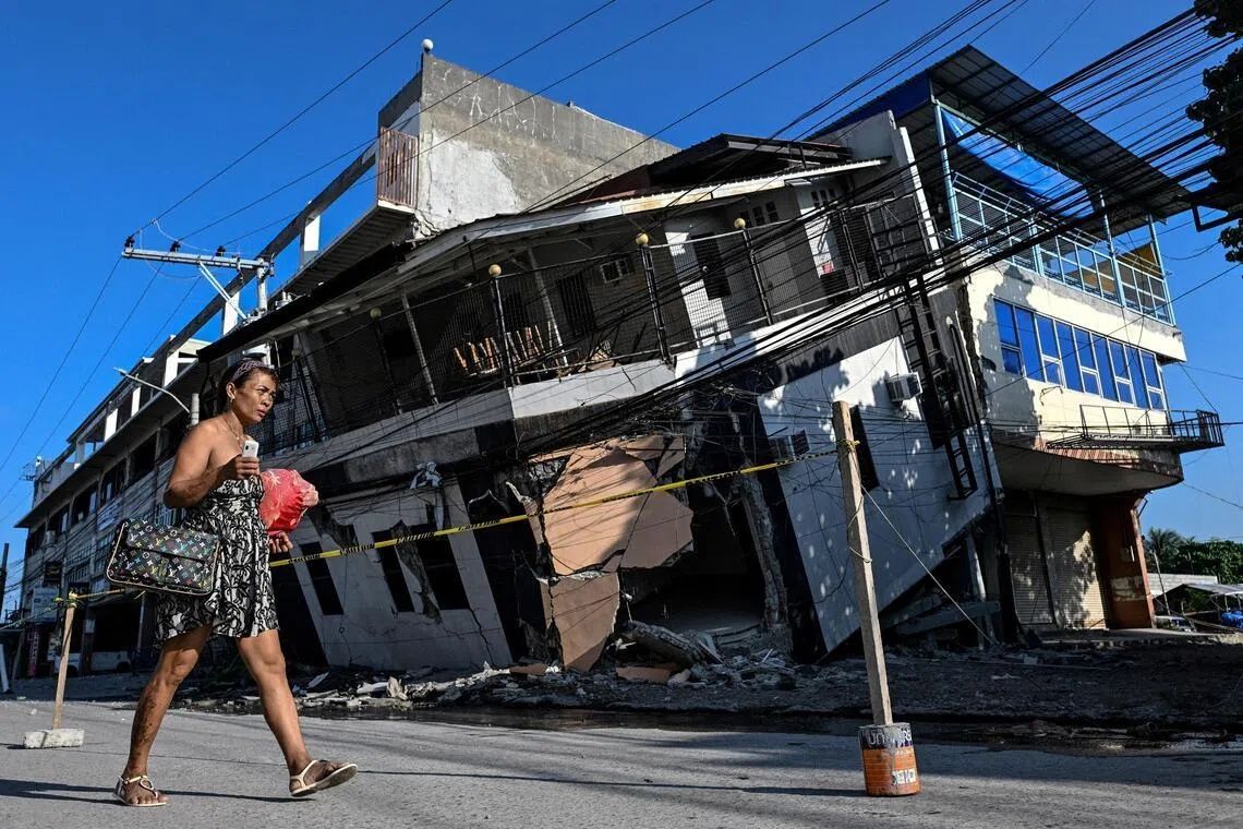
The June 8 earthquake that struck Mindanao's Sarangani province revealed one of nature's most unsettling transformations: the literal emergence of the seafloor. When Arsenio Butil Jr., a fisherman and pastor in Glan, first felt the powerful 7.8-magnitude tremor shake his coastal home, he watched in real time as the familiar shoreline shifted before his eyes. What had been water moments earlier became dry land, with newly exposed coral formations rising metres above the waves. The quake, which killed at least 76 people and damaged countless homes across the southern island, left behind a permanent geographical scar that has upended the lives of thousands who depend on these waters for survival and sustenance.
The mechanism behind this dramatic change lies in the Cotabato Trench, positioned as close as 50 kilometres offshore, where massive tectonic plates continuously grind against one another. When the two plates shifted during last week's seismic event, they forced the seabed upward in a process known to geologists as coastal uplift. The Philippines' seismology centre confirmed that the ocean floor rose approximately two metres in the affected region, extending the shoreline by as much as 200 metres in certain locations. The transformation stretched across nearly 100 kilometres, spanning multiple towns along the province's coast and creating a boundary that separates the old, familiar landscape from an entirely new one that residents scarcely recognise.
For people like Butil Jr., who witnessed the phenomenon firsthand, the experience was profoundly disturbing. He described watching the water recede several times, only to advance again in cycles that repeated three or four times as the quake's energy dissipated. Dead fish floated on the surface as marine life struggled to adapt to the suddenly altered conditions. The newly exposed seabed presents a jagged, skeletal landscape of bleached coral skeletons stretching for kilometres in both directions—a constant, ghostly reminder of the violent forces that reshaped their environment. These formations now stand as walls between fishing boats that once sat at the water's edge and the ocean they can no longer easily access.
Scientists emphasise that this coastal uplift, while extraordinary in scale and speed, represents a process that has unfolded continuously over thousands of years. The Cotabato Trench has been the site of frequent seismic activity throughout recorded history, with geological records indicating that similar adjustments have occurred repeatedly. What makes this event historically significant is not the phenomenon itself but rather the human witnesses and the documented modern context. A United Nations disaster risk reduction report released in mid-May had warned that a swarm of thousands of small earthquakes recorded in January could signal the approach of a major seismic event, providing authorities with advance notice that proved tragically insufficient to prevent casualties and displacement.
The psychological impact on residents cannot be overstated. In the hills above neighbouring villages, approximately 100 displaced people—mostly fishermen and their families—continue living in makeshift encampments rather than returning to their destroyed homes. Datu Atom Malimpnig, a Maguindanaon chieftain representing these communities, explained that the permanently altered shoreline has generated widespread fear among the population. Beyond the material loss of their homes and boats, people harbour deep concerns that the dramatic seabed movement could trigger a tsunami. Though seismic specialists indicate such fears may be misplaced in this particular case, residents reasonably prefer the safety of elevated ground to the uncertainty of coastal living in the aftermath of such a dramatic geological event.
The economic ramifications extend beyond displaced fishing families to the tourism sector, which has emerged as an increasingly important revenue source for the region. Edzel Baylon, a staff member at Isla Jardin del Mar resort, described the newly formed landscape as economically catastrophic for a business model predicated on pristine white sand beaches and accessible swimming. The exposed coral and dramatically shallowed waters have rendered the beachfront unsuitable for the leisure activities that attract paying visitors. What was previously the resort's primary asset—direct access to clear, swimmable water—has been replaced by a decidedly uninviting expanse of dead coral and shallow channels. Tourism operators throughout the affected region now face the difficult task of reimagining their business models around permanently altered geography.
The vulnerability of this region to continued seismic activity adds another layer of concern to reconstruction and resettlement planning. Since the June 8 earthquake, more than 8,500 aftershocks have rattled the region, keeping nerves frayed and families on edge. Butil Jr. noted that the ground itself bears visible evidence of severe damage—long cracks spider-web across the landscape, warning of structural instability that could be catastrophically exacerbated by even moderately sized subsequent tremors. This ongoing hazard means that rebuilding must be approached with exceptional care, considering not just the recovery from this single event but the necessity of constructing resilience against future seismic activity.
For Malaysian and broader Southeast Asian observers, this event carries important implications regarding earthquake risk in the broader region. The Philippines sits along the Pacific Ring of Fire, a zone characterised by extraordinary tectonic activity, but similar stress accumulation occurs throughout Southeast Asia, including along faults that extend toward Malaysia and Indonesia. The mechanisms that created this permanent coastal change operate across multiple subduction zones and trench systems throughout the region. The disaster also underscores how scientific monitoring, while increasingly sophisticated, cannot yet reliably prevent casualties, and how geological processes can transform entire landscapes within seconds, overwhelming traditional infrastructure and forcing rapid abandonment of long-occupied settlements.
The broader challenge now facing Philippine authorities involves coordinating disaster response, housing reconstruction, economic support for affected communities, and long-term risk management across multiple affected municipalities. Local communities must decide whether to rebuild in fundamentally altered locations or attempt to resettle inland, abandoning ancestral lands that no longer functionally serve their traditional purposes. Government support workers are currently providing emergency relief such as food distributions, but the scale of permanent relocation required suggests that recovery will extend across years, not months. The visible transformation of the coastline serves as a permanent testament to the power of tectonic forces and the delicate relationship between human settlement and geological realities that operate on timescales humans rarely witness directly.
As Arsenio Butil Jr. and his community contemplate their future, they do so against a backdrop of not merely destroyed homes but an entirely reconfigured geography. The immediate aftermath found residents cautiously optimistic about eventual recovery, yet acutely aware that their environment has fundamentally changed in ways that cannot be reversed. Each aftershock, including a 5.4-magnitude tremor that struck even as researchers were documenting the disaster, serves as a reminder that the tectonic processes underlying this transformation remain active. The resilience of affected communities will be tested not only by immediate reconstruction challenges but by the need to develop new relationships with a landscape that has become, in very real terms, a different place than the one their ancestors knew.